DOI:10.29111/ijlrst ISRA Impact Factor:3.35

Research Paper Open Access
International Journal of Latest Research in Science and Technology Vol.3 Issue 4, pp 18-21,Year 2014
Correspondence should be addressed to :
Received : 18 July 2014; Accepted : 31 July 2014 ; Published : 31 August 2014
| Download | 125 |
|---|---|
| View | 183 |
| Article No. | 10348 |
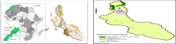
The watershed of Wadi Boumoussa (high Chaouia, La Meseta , Morocco ) is characterized by a sub-Mediterranean climate. Erratic rainfall, combined with a significant agricultural mechanization, causing damage". Severe erosion. Soils are increasingly degraded.The integration of thematic maps of various factors of universal soil loss equation in the Geographic Information System (GIS - Mapinfo) with their databases, allowed a fast and effective way to unravel the complexity and the interdependence of the factors in the analysis of risk of erosion, to better understand the impact of each factor and to assess its contribution to soil loss. Integration into the GIS formulas of universal soil loss equation has produced a synthetic map of the distribution of degrees of tb (DGDC erosion, determines the rate of erosion by sheet runoff ( 25t / ha / year on average) and to establish the key factors that control water erosion are , in order of importance , slope, soil erodibility and vegetation cover . This work can be used to calculate the erosion potential in other similar basins in the plains and plateaus experiencing sheet erosion " sheet erosion".
Copyright © 2014 Lhoussaine Mahdioui et al. This is an open access article distributed under the Creative Commons Attribution 4.0 International (CC BY 4.0) license which permits unrestricted use, distribution, and reproduction in any medium, provided the original work is properly cited.
Lhoussaine Mahdioui, Hmmad Chalrhami, Hakim Allali, Jamal Naja,Aouatif Bakkali , " Spatial Modeling And Assessment Of Soil Loss Of Watershed Oued Bou Moussa, High Chaouia, Settat, Morocco ", International Journal of Latest Research in Science and Technology . Vol. 3, Issue 4, pp 18-21 , 2014

MNK Publication was founded in 2012 to upholder revolutionary ideas that would advance the research and practice of business and management. Today, we comply with to advance fresh thinking in latest scientific fields where we think we can make a real difference and growth now also including medical and social care, education,management and engineering.

We offers several opportunities for partnership and tie-up with individual, corporate and organizational level. We are working on the open access platform. Editors, authors, readers, librarians and conference organizer can work together. We are giving open opportunities to all. Our team is always willing to work and collaborate to promote open access publication.
Our Journals provide one of the strongest International open access platform for research communities. Our conference proceeding services provide conference organizers a privileged platform for publishing extended conference papers as journal publications. It is deliberated to disseminate scientific research and to establish long term International collaborations and partnerships with academic communities and conference organizers.