DOI:10.29111/ijlrst ISRA Impact Factor:3.35

Research Paper Open Access
International Journal of Latest Research in Science and Technology Vol.3 Issue 3, pp 186-189,Year 2014
Correspondence should be addressed to :
Received : 26 June 2014; Accepted : 28 June 2014 ; Published : 30 June 2014
| Download | 125 |
|---|---|
| View | 179 |
| Article No. | 10338 |
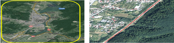
Everyone today recognizes that photogrammetry has been the leader among the remote sensing techniques and now LIDAR has carved a niche for itself. Because there are two strong remote sensing options and also their final products are similar in quality, this study is concerned with the integration of photogrammetric and LiDAR data to achieve a more complete surface description and Digital Terrain Model. The main objectives of this work include the combination of data acquired by photogrammetric techniques and LiDAR. It also considers the development of a method for a better integration of models. Using an irregular grid points were made interpolations of the two models and have done profiles on the border between models. Finally, spline surfaces were deterninated and were associated with the initial models in order to improve the integrated model.
Copyright © 2014 Paula Anca et al. This is an open access article distributed under the Creative Commons Attribution 4.0 International (CC BY 4.0) license which permits unrestricted use, distribution, and reproduction in any medium, provided the original work is properly cited.
Paula Anca, FlorentinBoda, Dan Raducanu, Virgil Dulgheru , " Combining Lidar And Photogrammetric Data For Obtaining A Digital Terrain Model ", International Journal of Latest Research in Science and Technology . Vol. 3, Issue 3, pp 186-189 , 2014

MNK Publication was founded in 2012 to upholder revolutionary ideas that would advance the research and practice of business and management. Today, we comply with to advance fresh thinking in latest scientific fields where we think we can make a real difference and growth now also including medical and social care, education,management and engineering.

We offers several opportunities for partnership and tie-up with individual, corporate and organizational level. We are working on the open access platform. Editors, authors, readers, librarians and conference organizer can work together. We are giving open opportunities to all. Our team is always willing to work and collaborate to promote open access publication.
Our Journals provide one of the strongest International open access platform for research communities. Our conference proceeding services provide conference organizers a privileged platform for publishing extended conference papers as journal publications. It is deliberated to disseminate scientific research and to establish long term International collaborations and partnerships with academic communities and conference organizers.